Earth Science
|
Welcome to earth science! you'll be learning about the earth/sun/moon, tectonic plates, and topographic maps. Hope you like it, have fun!
|
|
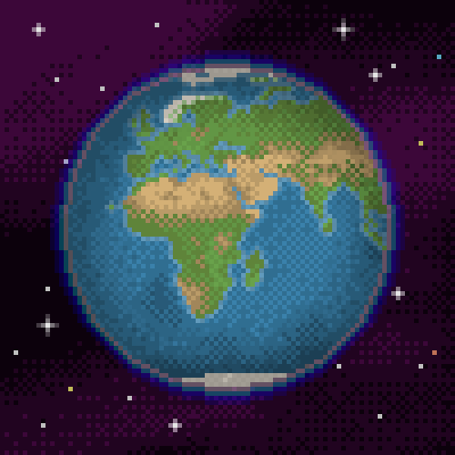
Earth, Moon, and Sun
|
KEY TERMS
*Rotation: turning around on an axis *Orbit: the curved path, usually elliptical, described by a planet, satellite, spaceship, etc., around a celestial body, as the sun. *hemisphere: half of the terrestrial globe or celestial sphere, especially one of the halves into which the earth is divided. 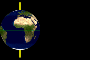
|
GENERAL INFO
One of the first things you need to know about the relationships between the earth, sun, and moon is the day and night. The earth is tilted on its axis, pointing towards the north star. While the earth rotates, orbits the sun, causing day and night. This leads into seasons, which are very similarly explained. The earth orbits/revolves around the sin, and with its tilt, creates seasons. The sunlight hits different portions (hemispheres) of the earth, so one half of earth will get sun, while the other gets hardly any warmth. This is why the northern and southern hemispheres are opposites with seasons; if the northern half is in summer, that means the axis is tilted toward the sun, but if it's tilted away, its summer for the southern half. One simple way to tell what order the seasons are in is to refer to the one before it. If the previous season is winter, the next one will be spring. Now onto earth's relationship with the moon. The gravitational attraction of the moon pulls the earth's oceans, causing them to bulge outward. The different phases of the moon cause spring and neap tides. Spring tides occur on full and new moon phases, while neap tides are on quarter moons. |
Earth, Moon, and Sun (pt. 2, lunar cycles)
|
KEY TERMS
*Waxing: the act or process of applying wax, as in polishing or filling. *Waning: to decrease in strength and intensity or to draw to a close. *Crescent: the figure of the moon in its first or last quarter, resembling a segment of a ring tapering to points at the ends. 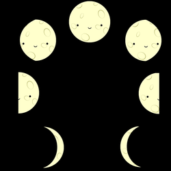
|
With the lunar cycle, the main thing you must remember is the sequence of phases. Keep in mind that whatever cycle that happens in the northern hemisphere is the opposite for the southern. In the phases, It usually starts with a new moon, meaning the moon is between the earth and the sun. New moons have no illumination, so they're 'new'. After the new moon comes a waxing crescent, and for the northern hemisphere, waxing = light on the right. Next is a first quarter, meaning the right half of the moon is illuminated. Then is waxing gibbous, the majority of the moon being lit up. Next (you probably guessed already) is a full moon, where the entire moon is illuminated (obviously). next is a waning gibbous, then a last quarter (left half is light up), and a waning crescent. Then finally, it circles back to a new moon. All of this takes place in the span of about four weeks, or what scientists refer to as a "lunar month".
|
Tectonic Plates
|
KEY TERMS
*Tectonic: of or relating to building or construction; constructive; architectural. *Theory: a coherent group of tested general propositions, commonly regarded as correct, that can be used as principles of explanation and prediction for a class of phenomena. *Pangaea: the hypothetical landmass that existed when all continents were joined, from about 300 to 200 million years ago. *Continental Drift: the lateral movement of continents resulting from the motion of crustal plates. *Divergent: differing or deviating. *Convergent: merging *transform: to change in form, appearance, or structure. |
Tectonic plates and the entire study of them all originated from a theory created by German geophysicist Alfred Wegener in 1915. He had noticed that, when rearranged, the earth's continents seem to fit together like puzzle pieces and form a super-continent known as Pangaea. However, the board of scientists had dismissed his ideas, and the theory wasn't revisited until much later. In the mid 1950-60's, while conducting nuclear testing, scientists discovered plate edges through magnetic surveys of the ocean floor. More studies showed that fossils from other continents would match those found in their 'puzzle piece' counterparts. This indicated seafloor-spreading, where new plate material is born. This was what shifted the Theory of Continental Drift into the Theory of Plate Tectonics. Plate tectonics come together at what are known as plate boundaries. When these plates shift, they form changes in the crustal features.
There is... *Transform boundaries *Convergent boundaries *Divergent boundaries Transform boundaries happen when two plates rub together, which causes earthquakes, volcanoes, etc. Convergent are when the plates converge, or push together. During this process, one plate will often slip under the other plate, causing subduction (with sea plates) and mountains. Plates can also diverge, meaning they separate from each other. This boundary causes seafloor-spreading and deep ocean trenches, as well as rift valleys. 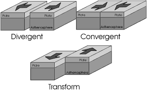
|
Topographic Maps
|
KEY TERMS
*Topography: the relief features or surface configuration of an area. *Contour line: a line joining points of equal elevation on a surface. *Township line: one of two parallel lines running east and west that define the north and south borders of a township. 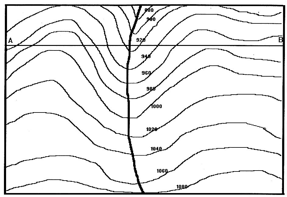
|
GENERAL INFO
Topographic maps, which are primarily used in architectural situations and describe natural features. They're most commonly used to show hills or mountains, which include streams. Contour lines are used to show elevation on the map, and depending on the spacing of them, shows the steepness of the geographical feature; the farther apart the lines are, the less steep the incline is. The shape of the lines also determines whether or not the feature is a mountain or a hill. If they form rings like a bullseye, its a hill. If its a jagged, more asymmetrical shape its a mountain. When graphing streams or rivers on topographic maps, remember: The contour lines point upstream and the water flows out of a 'v'. 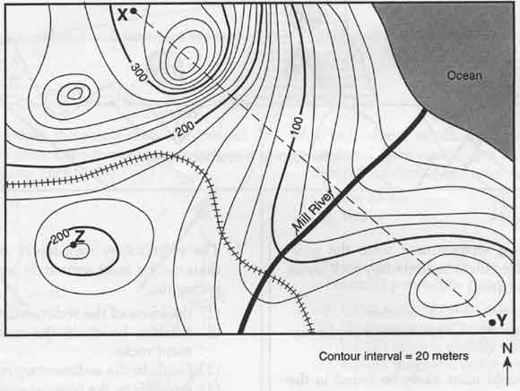
|
